Now Reading: Polar Vortex 2025: What to Expect This Winter
-
01
Polar Vortex 2025: What to Expect This Winter
Get ready to bundle up! As winter approaches, you might be hearing whispers and forecasts about a potential polar vortex 2025 event. But what exactly does that mean? Is it a frozen hurricane, an arctic apocalypse, or just another chilly winter day? Don’t worry, we’re here to break it all down for you.
This guide will explain the science behind the polar vortex in simple terms, explore what a polar vortex 2025 could mean for weather across the United States, and give you practical tips to stay safe and warm. We’ll separate the myths from the facts and help you understand how this massive weather pattern high up in the atmosphere can send a blast of frigid air right to your doorstep.
Key Takeaways
- What is the Polar Vortex? The polar vortex is a large area of low pressure and cold air that always exists at the North and South Poles. It’s not a storm that hits the ground but a high-altitude phenomenon that can influence our weather.
- A “Polar Vortex” Event: When we talk about a polar vortex event, it means the vortex has weakened or been disrupted, allowing frigid arctic air to spill southward into places like the United States, Europe, and Asia.
- Predicting the Polar Vortex 2025: Scientists use advanced computer models to predict the behavior of the polar vortex. While long-range forecasting is challenging, current indicators can suggest a higher or lower probability of a disruption.
- Impact on the US: A weakened polar vortex can lead to record-breaking cold, heavy snowfall, and icy conditions, primarily affecting the Midwest, Northeast, and even southern states.
- Preparation is Key: Preparing for a potential polar vortex 2025 event involves getting your home ready for extreme cold, having an emergency kit, and knowing how to stay safe both indoors and outdoors.
What Exactly Is the Polar Vortex?
Before we dive into what a polar vortex 2025 might look like, let’s clear up a common misconception. The polar vortex isn’t a storm you can see on a weather map like a hurricane or a blizzard. Instead, it’s a permanent, large-scale circulation of cold air that swirls around the Arctic, high up in the stratosphere—about 10 to 30 miles above the Earth’s surface. Think of it as a massive, spinning top of frigid air that stays contained over the North Pole for most of the year.
A strong and stable polar vortex is actually good for those of us living in the mid-latitudes. When it’s spinning quickly and tightly, it acts like a fence, keeping the coldest air locked up in the Arctic. This usually means a milder winter for much of the United States. It’s when this fence breaks down that we start to have problems. Meteorologists have known about the polar vortex for decades, but the term only entered the popular vocabulary after a major event in 2014 brought historic cold to North America.
The Science Behind the Vortex
The polar vortex is strongest during the winter when the temperature difference between the polar regions and the equator is most extreme. This difference in temperature drives the powerful jet stream, a fast-moving river of air that circles the globe. The polar vortex sits above the jet stream and is closely linked to it.
The vortex is kept stable by a band of strong westerly winds. When these winds are powerful, the vortex remains a single, well-defined circulation. However, sometimes large weather patterns in the lower atmosphere, like powerful storms over the Pacific, can send strong atmospheric waves upward. These waves can crash into the stratosphere and disrupt the vortex, much like a spinning top being knocked off balance. This disruption can cause the vortex to warm up suddenly, weaken, stretch, or even split into two or more smaller “sister” vortices.
Weak Vortex vs. Strong Vortex
Understanding the difference between a strong and weak vortex is crucial to predicting winter weather.
- Strong Polar Vortex: When the vortex is strong, the winds circling it are fast and consistent. This locks the cold air in place over the Arctic. The jet stream tends to flow in a relatively straight, zonal pattern from west to east. For the United States, this often means that winter storms are less intense, and arctic air outbreaks are infrequent. We experience more “normal” or even milder-than-average winter conditions.
- Weak Polar Vortex: A weak polar vortex is the opposite. The winds slow down, and the vortex becomes wavy and distorted. It can wobble off the pole or split apart. When this happens, the frigid air it normally contains can escape and plunge southward. This displacement pushes the jet stream into a wavier, more meridional pattern, creating deep troughs of low pressure that allow arctic air to invade the U.S. and Europe, leading to what we call a “polar vortex event.”
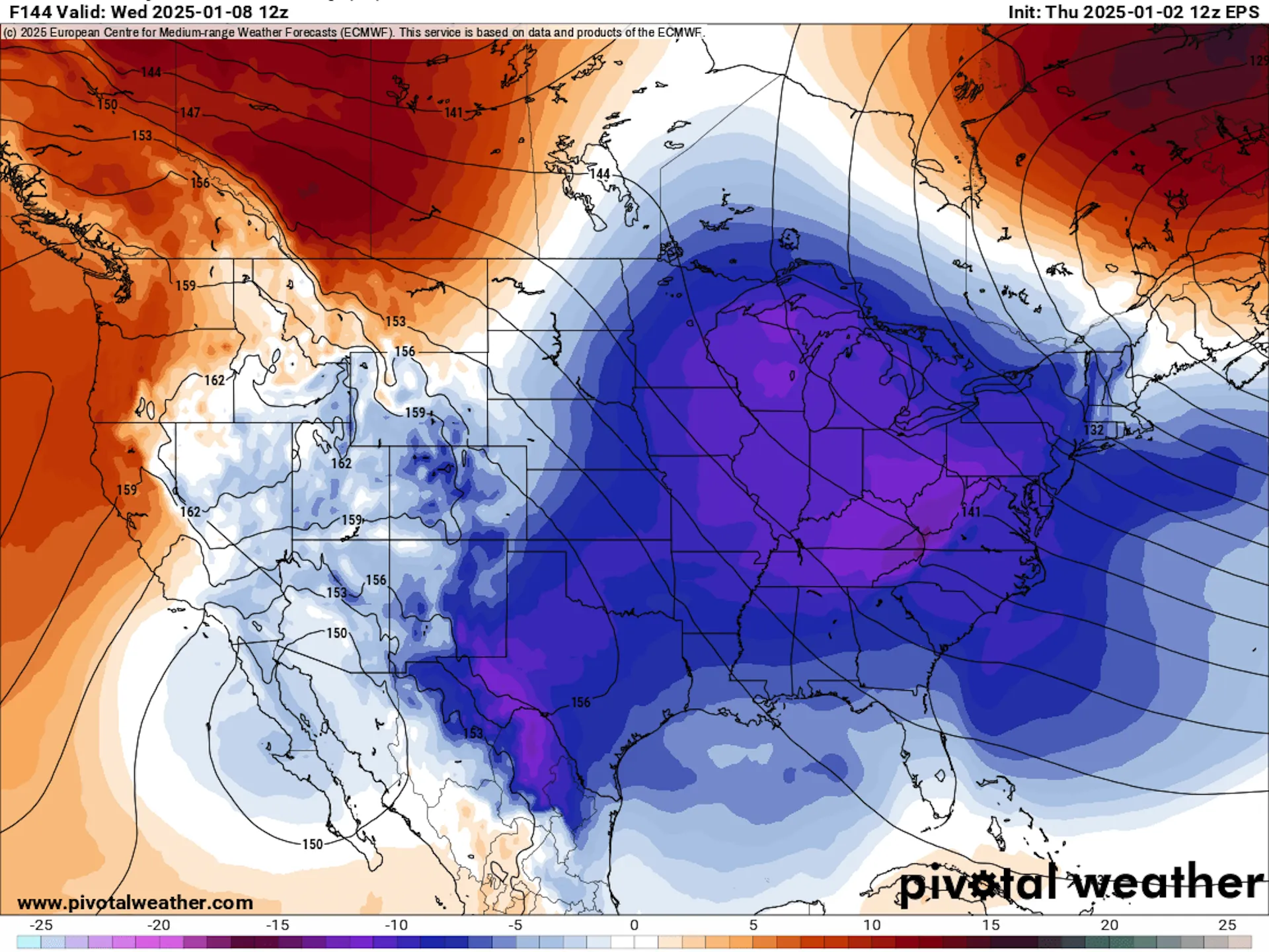
Predicting a Polar Vortex 2025 Event
So, how do scientists know if we’re in for a visit from the polar vortex? Forecasting a polar vortex 2025 event isn’t about looking out the window; it involves complex computer modeling and monitoring conditions high up in the stratosphere. Meteorologists look for signs of a Sudden Stratospheric Warming (SSW) event, which is the primary trigger for a vortex breakdown. An SSW is exactly what it sounds like: a rapid and dramatic increase in temperature in the stratosphere over the polar region, sometimes by as much as 90°F (50°C) in just a few days.
This warming is caused by the atmospheric waves we mentioned earlier. When they break in the stratosphere, they reverse the direction of the winds that contain the vortex, causing it to weaken and spill its cold contents. There’s a lag effect; the impacts of an SSW aren’t felt at the surface immediately. It can take several weeks for the changes in the stratosphere to work their way down to the troposphere, where our weather happens. This lag gives forecasters a window to predict a coming cold snap. For the latest insights on global weather phenomena, platforms like Forbes Planet often provide detailed analysis.
What Do the Models Say About Winter 2025?
Long-range forecasting is one of the most challenging aspects of meteorology. Predicting the exact timing and intensity of a polar vortex 2025 disruption months in advance is nearly impossible. However, scientists can look at broader patterns, such as sea surface temperatures in the Pacific (like El Niño or La Niña) and snow cover extent in Siberia, which can influence the likelihood of an SSW event.
As of late 2024, forecasters are closely monitoring these global patterns. Some models might suggest a higher-than-average probability of a mid-winter SSW, which could increase the chances of a significant cold air outbreak in North America. Others might show a more stable pattern. It’s important to remember that these are probabilities, not certainties. The final forecast for a polar vortex 2025 event will become much clearer as we get closer to the heart of winter, typically in the December-to-February timeframe. Always rely on updates from trusted sources like the National Weather Service (NWS) for the most accurate, short-term forecasts.
How a Polar Vortex Event Affects the United States
When the polar vortex weakens and sends a lobe of arctic air southward, the impact across the United States can be dramatic and widespread. The exact location and severity of the cold depend on the shape of the jet stream trough. Typically, the coldest air plunges into the Upper Midwest, the Great Lakes region, and the Northeast. However, these outbreaks can be so intense that they push freezing temperatures all the way down to the Gulf Coast.
Regional Impacts: Who Gets Hit Hardest?
Different parts of the country experience a polar vortex event in different ways.
The Midwest and Northeast
These regions are often ground zero for a polar vortex-driven cold snap. Cities like Chicago, Minneapolis, Boston, and New York can experience days or even weeks of dangerously low temperatures, often accompanied by brutal wind chills that can drop to -30°F, -40°F, or even lower. This extreme cold puts immense strain on infrastructure, causing pipes to burst, power grids to fail, and transportation to grind to a halt. Lake-effect snow bands can become particularly intense, dumping feet of snow on areas downwind of the Great Lakes.
The South
While the South doesn’t get the same level of sustained cold, a polar vortex event can still bring a major shock to the system. A dip in the jet stream can funnel freezing temperatures into states like Texas, Louisiana, and Florida. Since these regions are not accustomed to or equipped for such cold, the impacts can be severe. A few inches of snow or ice can shut down entire cities, and widespread power outages can become life-threatening when homes are not properly insulated for arctic conditions.
The West Coast
Interestingly, the West Coast often experiences the opposite effect during a polar vortex event in the East. The same wavy jet stream that brings a deep trough of cold air to the eastern half of the country often creates a large ridge of high pressure over the West. This typically leads to unusually mild, dry, and sunny weather from California to Washington. While it might seem nice, a prolonged dry spell during the winter can worsen drought conditions and reduce the mountain snowpack, which is vital for the region’s water supply.
Debunking Common Polar Vortex Myths
The term “polar vortex” sounds dramatic, and it has inspired a lot of myths and misunderstandings. Let’s separate fact from fiction.
Myth 1: The polar vortex is a new phenomenon.
Fact: The polar vortex is a permanent feature of our atmosphere that has existed for as long as the Earth has had seasons. Scientists have been studying it for over 70 years. It only became a household name recently because of its connection to headline-grabbing cold snaps.
Myth 2: The polar vortex is a storm that will hit my town.
Fact: The vortex itself stays in the stratosphere, miles above the ground. It’s not a physical storm like a hurricane. What we feel at the surface is the effect of a weakened vortex—the southward plunge of arctic air it displaces.
Myth 3: Every cold winter day is caused by the polar vortex.
Fact: Winters are cold! Most cold days are just part of a normal winter weather pattern. A true “polar vortex event” refers to an unusually severe and prolonged outbreak of arctic air directly linked to a disruption of the stratospheric vortex. These are exceptional, not routine, events.
Myth 4: A polar vortex event means the end of global warming.
Fact: This is a critical misunderstanding. A cold snap in one part of the world doesn’t negate the long-term global warming trend. Some research even suggests that a warming Arctic could be contributing to a less stable polar vortex, potentially leading to more frequent disruptions. The planet as a whole continues to warm, even if we experience bouts of extreme cold locally.
How to Prepare for a Polar Vortex 2025 Event
Being prepared is the best defense against extreme cold. Whether a major polar vortex 2025 event materializes or not, these tips will help you stay safe during any severe winter weather.
Preparing Your Home
Your home is your primary shelter, so make sure it’s ready to withstand arctic temperatures.
- Insulate, Insulate, Insulate: Check for drafts around windows and doors and seal them with weatherstripping or caulk. Ensure your attic and walls have adequate insulation to prevent heat from escaping.
- Protect Your Pipes: The biggest risk during extreme cold is bursting pipes. Insulate any pipes in unheated areas like basements, crawl spaces, or attics. During a severe cold snap, let faucets drip slowly to keep water moving. Know where your main water shutoff valve is in case a pipe does burst.
- Service Your Heating System: Have your furnace or boiler professionally inspected before winter arrives to ensure it’s running efficiently and safely.
- Have Backup Heat: If you have a fireplace or a wood-burning stove, make sure it’s clean and you have plenty of fuel. Consider a space heater that is rated for indoor use, and always follow safety instructions—never leave it unattended.
Creating a Winter Emergency Kit
Power outages are common during extreme cold. A well-stocked emergency kit can be a lifesaver.
|
Category |
Items to Include |
|---|---|
|
Light & Power |
Flashlights, extra batteries, a portable power bank for charging phones |
|
Food & Water |
At least a three-day supply of non-perishable food and one gallon of water per person, per day |
|
Warmth |
Extra blankets, sleeping bags, warm coats, hats, gloves, and scarves |
|
First Aid |
A standard first aid kit, plus any necessary prescription medications |
|
Information |
A battery-powered or hand-crank radio to receive weather updates |
Staying Safe During Extreme Cold
When the temperatures plummet, you need to take precautions whether you’re indoors or outdoors.
- Dress in Layers: If you must go outside, wear several layers of loose-fitting, lightweight clothing. The outer layer should be wind and water-resistant. Don’t forget a warm hat, gloves or mittens, a scarf to cover your face and mouth, and waterproof boots.
- Recognize Frostbite and Hypothermia: Learn the signs of these dangerous conditions.
-
- Frostbite: Numbness, loss of feeling, and a white or grayish-yellow skin area.
- Hypothermia: Shivering, exhaustion, confusion, fumbling hands, memory loss, and slurred speech. If you suspect someone has hypothermia, get them to a warm location immediately and seek medical help.
- Check on Others: Look in on elderly neighbors, families with young children, and those who live alone. Extreme cold is especially dangerous for vulnerable populations.
- Bring Pets Inside: If it’s too cold for you, it’s too cold for your pets. Bring all animals indoors during a cold snap.
Conclusion
The term polar vortex 2025 can sound intimidating, but understanding the science behind it helps demystify the phenomenon. It’s not a storm to fear, but a high-altitude weather pattern to respect. Its behavior can have a profound impact on our winter, bringing either mild conditions or a blast of life-threatening cold. While we can’t control the vortex, we can control how prepared we are.
By taking sensible steps to ready your home, create an emergency plan, and learn how to stay safe in extreme cold, you can face whatever winter throws your way. Stay informed by following reliable weather sources, and use the coming weeks to prepare. That way, if the polar vortex 2025 does decide to pay a visit, you and your family will be ready to weather the chill safely and comfortably.
Frequently Asked Questions (FAQ)
Q1: How long does a polar vortex cold snap usually last?
A: A cold air outbreak driven by the polar vortex can last for several days to over a week. The duration depends on how long the jet stream pattern remains locked in place.
Q2: Is the polar vortex the same thing as the jet stream?
A: No, but they are related. The polar vortex is a circulation of air in the stratosphere, while the jet stream is a fast-moving river of air lower down in the troposphere. A weakening of the polar vortex can cause the jet stream to become wavier, which helps transport the cold arctic air southward.
Q3: Can a polar vortex event happen in the summer?
A: No. The polar vortex is a winter phenomenon. It weakens and often disappears completely during the summer when the Arctic is in 24-hour daylight and the temperature difference between the pole and the equator is minimal.
Q4: Does a weak polar vortex guarantee a cold winter?
A: Not necessarily. A weak vortex increases the probability of a major cold air outbreak, but it doesn’t guarantee one. The exact timing and location of the cold air depend on many other factors in the atmosphere. Sometimes the cold air can be displaced over Siberia or Europe instead of North America.
Q5: Where can I get the most reliable forecast for a polar vortex 2025 event?
A: For official warnings and local forecasts, the most reliable source is the National Weather Service (NWS) and its local branches. For long-range outlooks and scientific explanations, you can follow updates from NOAA’s Climate Prediction Center.
Heard talk of a “polar vortex 2025” and wondering what it means for your winter? 🥶 Don’t worry, it’s not a frozen hurricane!
It’s a massive weather pattern high in the atmosphere that can send a blast of arctic air our way. A disruption could mean record-breaking cold and snow for parts of the US.
Want to separate fact from myth and get practical tips to prepare your home and family? Read our full guide to stay warm and safe this winter!
#PolarVortex #Winter2025 #WeatherPrep
Stay Informed With the Latest & Most Important News
Previous Post
Next Post


Advertisement