Now Reading: Understanding the Frequent Indonesia Earthquake Phenomenon: Causes, History, and Safety
-
01
Understanding the Frequent Indonesia Earthquake Phenomenon: Causes, History, and Safety
Understanding the Frequent Indonesia Earthquake Phenomenon: Causes, History, and Safety
An Indonesia earthquake is a phrase that appears in the news far too often. If you have ever wondered why this beautiful island nation experiences so much shaking, you are not alone. Indonesia is a country of stunning landscapes, lush rainforests, and vibrant culture, but it sits on one of the most geologically active spots on Earth. For students, travelers, and science enthusiasts in the United States, understanding why these events happen is fascinating and important. It helps us appreciate the raw power of our planet and the resilience of the people who call these islands home.
When we talk about an Indonesia earthquake, we aren’t just talking about a single event. We are looking at a complex pattern of geological activity that has shaped the region for millions of years. From minor tremors that rattle teacups to massive quakes that reshape coastlines, the seismic activity here is constant. In this article, we will dive deep into the science behind the shaking, look at major historical events, and discuss how people prepare for these natural occurrences. We will explore the “Ring of Fire,” tectonic plates, and what you should know if you ever plan to visit this incredible archipelago.
Why Does an Indonesia Earthquake Happen So Frequently?
To understand why an Indonesia earthquake occurs, we first need to look at the map—but not the political map you see in social studies class. We need to look at a tectonic map. The earth’s outer shell isn’t one solid piece of rock; it’s broken into massive puzzle pieces called tectonic plates. Indonesia is located right where several of these giant plates crash into each other. It is like a busy intersection for the planet’s crust, and unfortunately, these plates don’t always merge smoothly.
The primary reason for the frequency of these earthquakes is the movement of the Indo-Australian Plate and the Eurasian Plate. The Indo-Australian Plate is constantly pushing northward, sliding under the Eurasian Plate. This process is called subduction. Imagine trying to slide a rough carpet under a heavy door; it gets stuck, tension builds up, and eventually, it slips forward with a sudden jerk. That sudden slip releases a massive amount of energy, which we feel as an earthquake. Because this movement is continuous, the threat of an Indonesia earthquake is always present.
The Pacific Ring of Fire Explained
You have probably heard the term “Ring of Fire” in science class or disaster movies. This isn’t just a catchy name; it is a very real geographic area. The Ring of Fire is a horseshoe-shaped path along the Pacific Ocean characterized by active volcanoes and frequent earthquakes. Indonesia sits right in the heart of this volatile zone. About 90% of the world’s earthquakes occur along the Ring of Fire, making it the most seismically active region on the planet.
Being part of the Ring of Fire means that Indonesia is surrounded by trenches and volcanic arcs. The geological forces here are incredible. Magma rises from deep within the Earth, creating volcanoes, while the shifting plates cause the ground to shake. This dual threat makes the region unique. When an Indonesia earthquake hits, it can sometimes trigger volcanic eruptions, or vice versa. It is a dynamic environment where the Earth is constantly reshaping itself, reminding us that the ground beneath our feet is alive and moving.
Tectonic Plate Collisions
The specific mechanics of an Indonesia earthquake often involve three major tectonic plates: the Pacific Plate, the Eurasian Plate, and the Indo-Australian Plate. It is a three-way collision that creates immense pressure. In eastern Indonesia, the situation is even more complex with smaller micro-plates adding to the chaos. This complex tectonic setting is why earthquakes can happen almost anywhere in the country, from the island of Sumatra in the west to Papua in the east.
When these plates collide, they can interact in different ways. Sometimes they crash head-on (convergent boundaries), sometimes they pull apart (divergent boundaries), and sometimes they slide past each other (transform boundaries). In Indonesia, subduction (crashing head-on where one slides under) is the most common cause of major quakes. The friction between the plates locks them together until the stress becomes too great. When the rock finally breaks, the stored energy is released as seismic waves, causing the ground to shake violently and resulting in what we know as an Indonesia earthquake.
Major Historical Earthquakes in Indonesia
History is filled with stories of powerful tremors in this region. Looking back at past events helps us understand the scale and danger of an Indonesia earthquake. Some of these events have changed the course of history and improved how the world responds to natural disasters. They serve as somber reminders of nature’s power and the importance of preparedness.
The list of significant earthquakes in Indonesia is long, but a few stand out due to their magnitude and the devastation they caused. These events are studied by scientists worldwide to better understand seismic patterns. They also highlight the vulnerability of coastal communities to the secondary effects of earthquakes, such as tsunamis and landslides. By remembering these events, we honor the victims and learn valuable lessons for the future.
The 2004 Indian Ocean Tsunami
Perhaps the most famous and devastating event was the 2004 Indian Ocean earthquake and tsunami. On December 26, 2004, a massive undersea Indonesia earthquake with a magnitude of 9.1–9.3 struck off the coast of Sumatra. It was one of the strongest earthquakes ever recorded. The shaking lasted for nearly ten minutes, which is an incredibly long time for an earthquake.
However, it wasn’t just the shaking that caused the destruction. The quake displaced a massive amount of water, triggering a tsunami that raced across the Indian Ocean. Waves as high as 100 feet hit the coast of Aceh in Indonesia before spreading to Thailand, Sri Lanka, India, and even Africa. It was a global tragedy that claimed over 227,000 lives. This event changed how the world monitors oceans, leading to the establishment of better tsunami warning systems. It stands as a tragic example of how an Indonesia earthquake can have global consequences.
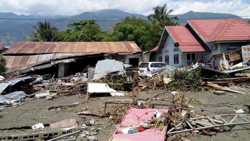
The 2018 Sulawesi Earthquake
More recently, in September 2018, a magnitude 7.5 Indonesia earthquake struck the Minahasa Peninsula on the island of Sulawesi. This event was particularly terrifying because of a phenomenon called liquefaction. Liquefaction happens when intense shaking turns solid soil into a liquid-like substance. Entire neighborhoods in the city of Palu were swallowed up as the ground turned to mud and flowed like a river.
This earthquake also triggered a localized tsunami that struck the city of Palu. The shape of the bay amplified the waves, causing significant destruction. Thousands of people lost their lives, and many more were displaced. This event highlighted the dangers of liquefaction, which is now a major consideration for urban planners and engineers in earthquake-prone zones. It showed that even a quake that isn’t a “megathrust” like 2004 can still be incredibly deadly depending on the local geology.
Recent Activity in 2024 and 2025
Seismic activity has not slowed down. In late 2025, reports of an Indonesia earthquake are still common news. For instance, in December 2025, several tremors were felt in regions like Sumatra and Sulawesi. While not all of them are catastrophic, the frequency is a constant reminder of the geological instability. Just recently, a magnitude 5.0 quake hit Gorontalo, and another struck North Sumatra.
These modern quakes are monitored closely by agencies like the USGS (United States Geological Survey) and BMKG (Indonesia’s meteorology, climatology, and geophysics agency). With better technology, we can now detect even small tremors that might have gone unnoticed in the past. This constant stream of data helps scientists refine their models and improve early warning systems. It is a continuous battle to stay one step ahead of the next big Indonesia earthquake.
The Connection Between Volcanoes and Earthquakes
There is a saying in geology: “Where there are earthquakes, there are often volcanoes.” This is certainly true for Indonesia. The forces that cause an Indonesia earthquake—subduction and plate movement—are the same forces that create volcanoes. As one tectonic plate slides beneath another, it descends into the hot mantle of the Earth. The extreme heat and pressure cause the rock to melt, creating magma.
This magma rises through the crust and erupts as a volcano. Indonesia has more active volcanoes than any other country in the world. Famous peaks like Mount Merapi, Mount Krakatoa, and Mount Bromo are all products of this tectonic activity. Sometimes, the movement of magma underground can trigger small earthquakes, known as volcanic earthquakes. Conversely, a large tectonic Indonesia earthquake can sometimes disturb a nearby volcano, potentially triggering an eruption.
How Magma Movement Causes Tremors
Before a volcano erupts, magma pushes its way up through rock layers. This pressure cracks the rocks, creating small, localized earthquakes. Scientists monitor these tremors very closely. If they see a swarm of small quakes near a volcano, it is often a sign that an eruption could be imminent. It serves as a natural warning bell for the people living on the slopes of these fire mountains.
While these volcanic earthquakes are usually smaller than the massive tectonic ones caused by plate collisions, they are still dangerous. They can cause landslides on the steep slopes of volcanoes or damage buildings in nearby villages. Understanding the link between volcanic activity and an Indonesia earthquake helps authorities decide when to evacuate people from danger zones. It is a delicate dance with nature that requires constant vigilance.
Risks: Tsunamis and Liquefaction
When an Indonesia earthquake strikes, the shaking is often just the beginning of the danger. The secondary effects can be far more deadly than the quake itself. We have already touched on tsunamis and liquefaction, but it is important to understand why they happen and how they differ. These are the “hidden” killers that often catch people off guard.
A tsunami is generated when the seafloor abruptly deforms and vertically displaces the overlying water. Because Indonesia is an archipelago (a group of islands), many of its fault lines are underwater. When these underwater faults rupture, they can launch massive waves toward the shore. Liquefaction, on the other hand, is a land-based horror. It happens in areas with sandy, water-saturated soil. When the ground shakes, the water pressure increases, pushing the sand grains apart and turning the ground into quicksand.
Understanding Liquefaction
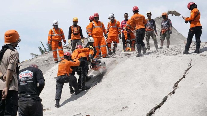
Liquefaction is one of the most terrifying aspects of an Indonesia earthquake. During the 2018 Palu event, videos showed houses literally sliding across the ground as the earth beneath them turned to soup. It makes rescue efforts incredibly difficult because the ground becomes unstable and unpredictable. Heavy machinery can sink, and roads can disappear instantly.
Engineering solutions can mitigate liquefaction, such as compacting the soil or installing deep foundations, but these are expensive and difficult to implement in existing cities. Awareness is the first step. Mapping areas prone to liquefaction helps city planners avoid building critical infrastructure like hospitals or schools in these high-risk zones. It is a crucial part of reducing the death toll from a future Indonesia earthquake.
|
Hazard |
Cause |
Primary Danger |
|---|---|---|
|
Ground Shaking |
Tectonic plates slipping |
Building collapse, falling debris |
|
Tsunami |
Underwater seafloor displacement |
Flooding, drowning, coastal destruction |
|
Liquefaction |
Intense shaking of wet, sandy soil |
Buildings sinking, ground sliding away |
|
Landslides |
Shaking on steep, unstable slopes |
Buried villages, blocked roads |
Measuring the Magnitude
You often hear numbers like “6.5” or “7.2” on the news after an Indonesia earthquake. But what do these numbers actually mean? Scientists use seismographs to measure the energy released by an earthquake. The most common scale used today is the Moment Magnitude Scale (Mw), which has largely replaced the older Richter Scale for larger quakes.
The scale is logarithmic, which is a fancy math term meaning that each whole number increase represents a huge jump in energy. A magnitude 7.0 earthquake is not just a little stronger than a 6.0; it releases about 32 times more energy! This is why a magnitude 9.0 Indonesia earthquake is a catastrophic, world-changing event, while a magnitude 5.0 might just knock some books off a shelf.
Why Depth Matters
Another crucial factor is the depth of the quake. An Indonesia earthquake can happen near the surface (shallow) or deep underground. Shallow earthquakes (0-70 km deep) are generally more dangerous because the energy has less distance to travel before it hits the surface. This results in more violent shaking for the people and buildings above.
Deep earthquakes (300-700 km deep) can be felt over a wider area, but the shaking is usually less intense by the time it reaches the surface. However, deep quakes are fascinating to scientists because they tell us about the movement of plates deep within the Earth’s mantle. When reading reports about an Indonesia earthquake, always look for the depth—it gives you a big clue about how damaging the event likely was.
Safety Tips for Travelers
Indonesia is a top travel destination for Americans. Bali, earthquakes aside, is a paradise. But if you are planning a trip to Bali, Jakarta, or Lombok, it is smart to be prepared. Knowing what to do in case of an Indonesia earthquake can save your life. It shouldn’t scare you away from visiting, but a little knowledge goes a long way.
Most modern hotels and resorts in Indonesia are built to withstand tremors. However, you might be out exploring a temple or hiking when a quake hits. The universal safety rule is “Drop, Cover, and Hold On.” Drop to your hands and knees so the earthquake doesn’t knock you down. Cover your head and neck with your arms, or get under a sturdy table. Hold on to your shelter until the shaking stops.
What to Do During a Tsunami Warning
If you are on the beach and feel a strong Indonesia earthquake, do not wait for a siren. The shaking is your warning. Move to higher ground immediately. If you can’t get to high ground, go inland as far as possible or up to the high floor of a sturdy concrete hotel.
Look for tsunami evacuation signs—they are common in coastal areas of Indonesia. Never go down to the beach to watch the water recede; this is a classic sign that a tsunami wave is approaching. Nature gives warnings, and listening to them is key. Being “tsunami smart” is just as important as packing sunscreen when you travel to this part of the world. For more travel insights and global updates, you can check out resources at https://forbesplanet.co.uk/ which covers a variety of international topics.
Building Codes and Infrastructure
One of the biggest challenges Indonesia faces is infrastructure. While modern skyscrapers in Jakarta are built with sophisticated dampers to absorb shock, many rural homes are made of unreinforced masonry. These brick and stone structures are very heavy and brittle, making them dangerous during an Indonesia earthquake. When they collapse, they crumble, causing severe injuries.
The Indonesian government is working hard to improve building codes and educate the public about safer construction methods. “Retrofitting” is the process of strengthening existing buildings, but it is costly and time-consuming. Simple changes, like tying the roof to the walls and reinforcing corners with concrete, can make a huge difference.
The Role of Education
Schools play a huge role in safety. Across Indonesia, students practice earthquake drills just like American students practice fire drills. They are taught to protect their heads and exit buildings calmly. This education is vital because children are often the most vulnerable during disasters.
Community organizations also run workshops on how to prepare “go-bags” with emergency supplies like water, flashlights, and first aid kits. Preparing for an Indonesia earthquake is a community effort. When neighbors know how to help neighbors, the survival rate during a disaster goes up significantly.
How Can You Help?
When a major Indonesia earthquake makes headlines, many people in the US want to help. The best way to assist is usually by donating money to reputable humanitarian organizations. Sending physical goods like clothes or canned food can actually clog up supply lines and create logistical nightmares for relief workers.
Organizations like the Red Cross, UNICEF, and Doctors Without Borders are often on the ground quickly. They know exactly what is needed, whether it is clean water, medical supplies, or temporary shelter. Financial donations allow them to buy supplies locally, which also helps stimulate the local economy that has been hit by the disaster.
- Donate Cash, Not Goods: Cash is flexible and fast.
- Research Charities: Make sure you are giving to a legitimate organization.
- Stay Informed: Follow news updates to see how recovery efforts are progressing.
Key Takeaways
- Location Matters: An Indonesia earthquake occurs frequently because the country sits on the “Ring of Fire,” a collision zone of major tectonic plates.
- Secondary Dangers: The shaking is dangerous, but tsunamis and soil liquefaction often cause the most casualties.
- Historical Impact: Massive events like the 2004 Tsunami have reshaped global disaster response and warning systems.
- Be Prepared: If visiting Indonesia, know the “Drop, Cover, and Hold On” drill and be aware of tsunami evacuation routes.
- Stay Updated: Modern technology allows for better monitoring, but prediction remains difficult. Always stay alert to local warnings.
Frequently Asked Questions (FAQ)
Q: Is it safe to travel to Indonesia despite the earthquakes?
A: Yes, millions of tourists visit safely every year. While the risk of an Indonesia earthquake is real, the chances of being caught in a major one are statistically low. Being prepared and staying in reputable accommodations increases your safety.
Q: Can scientists predict exactly when an Indonesia earthquake will happen?
A: No. Scientists can forecast probabilities (e.g., “there is a high chance of a quake in this area in the next 30 years”), but they cannot predict the exact time, date, or magnitude of an impending earthquake.
Q: What is the biggest Indonesia earthquake ever recorded?
A: The 2004 Sumatra-Andaman earthquake is the largest in recent history, with a magnitude of 9.1–9.3. It is one of the top three strongest earthquakes ever recorded globally.
Q: Why do some earthquakes cause tsunamis and others don’t?
A: Tsunamis are usually generated by shallow, underwater earthquakes where the tectonic plates move vertically, displacing a large volume of water. If the movement is horizontal (sliding past each other) or the quake is deep underground, a tsunami is unlikely.
Q: How often does a minor Indonesia earthquake occur?
A: Minor earthquakes happen almost daily in Indonesia. Most are too small to be felt by humans and are only detected by sensitive instruments.
Conclusion
The phenomenon of the Indonesia earthquake is a powerful reminder of our planet’s dynamic nature. For the people of Indonesia, it is a reality of daily life, met with resilience and adaptation. For the rest of us, it is a subject of scientific fascination and humanitarian concern. By understanding the causes—from shifting tectonic plates to the fiery volcanic arcs—we can better appreciate the challenges faced by this archipelago nation.
Whether you are a student researching geology, a traveler planning your next adventure, or simply a concerned global citizen, staying informed is key. We cannot stop the earth from shaking, but through science, preparation, and global cooperation, we can minimize the tragedy that often follows. If you want to learn more about the specific history of seismic events in this region, you can view the comprehensive list on the Wikipedia page for Earthquakes in Indonesia. Stay safe, stay curious, and always respect the power of nature.
Stay Informed With the Latest & Most Important News
Previous Post
Next Post


Advertisement